
This
page is the heart of Philly H2O, with links to documents, maps, images, and other
material that
I have been compiling since I began researching the City's watersheds
and sewer system in 1998. The most thorough way to search the site is to use the
Google search link on the HOME page. Another way is to browse through this list,
which includes most of the material on the site. Other material (including a wide
variety of MAPS, basic information at the DOWN UNDER! and
CREEK TO SEWER links,
and a brief resume of ADAM LEVINE) can be accessed from the
links at the left.
CLICK HERE FOR LATEST SITE UPDATES
NOTE
ON DOCUMENT TEXT
A number
of these documents have been converted to text using optical character recognition
(OCR) software, which is not an exact process. Please contact
me if you find any typos or other mistakes in these documents, so I can correct
them.
Also
contact me if you find any broken links, or if you have any material that
you would like to see included on PhillyH2O.
The History of Philadelphia's Watersheds and Sewers
Historical Consultant
Philadelphia Water Department
Overview of Sewer and Water History in Philadelphia
Water
and Sewer History Course
Seven-part course developed by Adam Levine, Ellen Freedman Schultz
and Drew Brown of PWD, focused on the development of Philadelphia
sewer and water systems.
Watersheds: General Information
Sewers,
Pollution, and Public Health in 19th Century Philadelphia by Adam Levine
This article first appeared in the May 2010 issue of Pennsylvania Legacies, published
by the Historical Society of Pennsylvania.
Geology
of Pennsylvania: A Government Survey (1858).
Excerpts and images
including geological and pictorial representations of Schuylkill River and Wissahickon
Creek, descriptions of the Potomac, Susquehanna, Delaware, and Allegheny watersheds
in Pennsylvania, and locations of quarries in Philadelphia and vicinity.
Fairmount
Dam Fishway on the Schuylkill.
Information on the new fishway, opened
in May 2009 to replace the Fairmount Dam Fish Ladder, and Includes photographs
and videos of fish (and one otter) passing through the fishway. Also many links
to other fish- and fishing-related pages. Among the links:
2008 PowerPoint
presentation on Fish Passage at Fairmount by Lance Butler and Joe Perillo, and
a 2005-2006 Fish Counts by Species at Fairmount Fish Ladder.
Fishing
in Philadelphia: Photographs from the Philadelphia Anglers Club.
Includes
photos of huge fish being taken out of the Schuylkill River and elsewhere in Philadelphia.
A second page of photos, Catch and Release,
documents big fish that took the bait more than once, and discusses the safety
of eating fish caught in urban environments. Thanks to Louis Cook of the
Philadelphia Anglers Club for providing information and gathering the photos for
these pages, from fellow Philly anglers Matt Coll, Tan Bui, Aki Mori, Chris McIntee,
Dan Coghlin, Dennis Cook, Enoch Lee, and Jude Becker.
Glossary
of Drainage Terms by C. Drew Brown
C.
Drew Brown, Manager of Public Education for PWD, created this glossary for our
annual Wingohocking Mystery Tour. I think it's too valuable to simply let lie
on some computer hard drive, so I got his permission to post it here.The terms
are not in alphabetical
order, but rather follow a logical hierarchy, beginning
with the proper definition of a watershed and working to smaller elements of both
natural and man-made drainage systems.
Watershed Histories
Gunner's Run (Aramingo Canal)
In Memory
of Patrolman Joseph A. Reiss, by George A. Shotzbarger
Patrolman Reiss died in the line of duty while investigating a Gunner's
Run Sewer sewer collapse on August 1, 1959. More than 50 years
later Shotzbarger, who at the time of the collapse was seven years old
and lived nearby, gave this eloquent speech at the dedication of a Hero
Plaque for Reiss, which talks about the sewer in the context of the
social history of the neighborhood. If anything on this site is a MUST
READ, this is it!
Kensington
Water Supply (1883) By
William W. Van Baun, M.D.
Located on
the Deleware River just below where the Aramingo Canal emptied into the river,
the Kensington Water Works served up a disgusting brew of polluted drinking water
for decades after it was opened in 1851. Health records from the period show a
higher death rate from typhoid fever and other water-borne diseases in the areas
served by this water works. The Board of Health advocated its closure many times,
as did independent physicians such as the author of this article. Unfortunately,
the works were not completely abandoned until 1890.
Aramingo
Canal: Then and Now.
Photos of the Aramingo Canal (Gunner's Run) being
converted into a combined sewer, 1900-1902, along with modern photos showing an
excavation of a section of the canal, December 2008. Thanks to Doug Mooney of
URS Corp., who headed the archaeological investigation, for inspiring this page
and providing modern photos, and to A. Leonard Pundt, for providing additional
modern photos.
Cobb's Creek and Delaware County
Cobbs Creek
Watershed History: An Online Slideshow and other Information.
One
of the first projects I undertook for the PWD Office of Watersheds in 2002 was
a history of the Cobbs Creek Watershed in Philadelphia. This page links to an
online slideshow of the watershed history, and other Cobbs-related material on
Phillyh2o.
Geological map of Delaware County [Pennsylvania]…1882. [Part of] Second Geological Survey of Pennsylvania. Report of progress C5. Part 1. Field Notes in Delaware County, by C. [Charles] E. Hall, with a colored geological map of the county, and thirty-nine photographic pictures of the granite quarries, the kaolin mines, the serpentine outcrops, and the castle rocks, published in advance of the Geological Report on Delaware County, part 2, by J. P. Lesley."
Cobbs
Creek Watershed: A collection of newspaper clippings
Several dozen
clippings from the Bulletin Collection, Temple University Libraries Urban Archives.
Abington,
Cheltenham, Darby, Horsham, Moreland and Upper Darby Townships
Plates from early 1870s atlases published by G. M. Hopkins, Philadelphia surveyor
and cartographer.
Cobbs
Creek Watershed: A Brief Historical Overview
A brief written survey
of some of the major issues of the watershed over the past 300 years.
Cobbs
Creek in the Days of the Old Powder Mill
by John Eckfeldt M.D. 1917.
A brief illustrated history of the section of Cobbs Creek outside Philadelphia,
written at a time when most of the evidence of that history was fast disappearing
due to residential development.
Report
on the Flood of 1843 in Delaware County, Pennsylvania
Written
in 1844 and reprinted in 1911, this long, detailed report provides a fascinating
glimpse of a horrendous flood that destroyed hundreds of bridges, mills and houses
and killed nearly 20 people. Also available is the following:
Newspaper
Account of the Flood of 1843 in Delaware County, Pennsylvania
1826
Report of the Committee of Delaware County, on the subject of
Manufactories,
Unimproved Mill Seats, &c. in said County
Arranged by the creeks along which the mills were situated, this 1826 report
gives a detailed view of the area's former industrial past, providing the amount
and worth of products, number of employees and other information for the county's
158 mills. Streams mentioned include: Cobb's Creek, Darby Creek, Mukinipates Creek,
Crum Creek, Ridley Creek, Chester Creek, Green's Creek, Marcus Hook Creek, Naaman's
Creek, Buck Run and Brandywine Creek.
A Brief History of the Overbrook
Neighborhood of Philadelphia, focusing on Changes in the Natural Landscape
A report completed in 2002 that includes information on Mill Creek Sewer and
Indian Creek (a Cobbs Creek tributary) in West Philadelphia.
Frankford Creek and its Tributaries
Frankford Creek Watershed: A historical overview of the Philadelphia section.by Adam Levine, Historical Consultant, Philadelphia Water Department Office of Watersheds, May 2003 (Revised October 2009). For some reason I never posted this before, so here it is now; better late than never!
Army
Corps of Engineers and US Geological Service (USGS) Sinking Homes Studies
Fascinating surveys of several Philadelphia neighborhoods that grew up around
two buried streams, Wingohocking Creek and Wissinoming Creek. This report,
which included many photographs of the neighborhoods in question, is no longer
available on the Web, so I have posted two PDF files related to the study directly
on this site. The files include Mapping Buried Stream Valleys in Philadelphia,
Pennsylvania: USGS Fact Sheet FS–117–00 (2000), and Geographic
Information System Analysis of Topographic Change in Philadelphia, Pennsylvania,
During the Last Century By Peter G. Chirico and Jack B. Epstein. USGS Open
File Report 00-224 (2000).
Wingohocking
Sewer Outfall, Videos & Photos.
Some of these were taken by participants
of PWD's annual Wingohocking Creek Watershed Tour. For more information about
the Thanks to Chris Dougherty, Dave Tavani, and Youtube's Yashea for the content
on this page.
Filling
Low Land: A story of ash-dumping in the Wingohocking Creek watershed
An
excerpt from Utility Cars of Philadelphia (1971) by Dr. Harold E. Cox,
discussing one of the reasons the once-thriving Logan neighborhood has become
an abandoned wasteland.
Abington,
Cheltenham, Darby, Horsham, Moreland and Upper Darby Townships
Plates from early 1870s atlases published by G. M. Hopkins, Philadelphia surveyor
and cartographer.
1882
Report from the Army Corps of Engineers on Navigation in Frankford Creek.
Report, by future PWD Chief William Ludlow, indicates the need for dredging
and other work to restore the navigation channel in Frankford Creek. Includes
details of employment and materials used for several manufactories along the creek.
Two
bridges across Frankford Creek: 19th century photos from City Archives.
Photographs showing reconstructed bridges at Bridge
and Orthodox streets. Photos also show area in vicinity of Bridge Street, including
Tacony or Lennig Chemical Works (now Rohm & Haas) the Frankford Arsenal, and
other business.
History
of Belfield, by Sarah Logan Wistar Starr
1934
booklet about this estate, now part of the LaSalle University campus, in Philadelphia's
Olney section. Belfield and Little Wakefield still exist, as do remnants of the
Belfield's gardens, which are on a steep hillside in the Wingohocking Creek valley,
overlooking a section of Belfield Avenue (beneath which the creek now flows in
a large sewer). In the early 19th century Philadelphia artist Charles Willson
Peale lived on the estate.
Wingohocking
Creek Watershed, 1902.
Excerpts from a 1902 guidebook of Germantown
concerning the Winghocking watershed and other local history.
The
Frankford Creek Watershed in the context of the development of Philadelphia's
Sewers and Sewage Treatment System
This work was completed in 2002
as part of a project, for the PWD Office of Watersheds, which included the timeline
below.
Frankford Creek Historical
Timeline
This timeline focuses on changes in the creek channel to
facilitate storm drainage and flood control, and development of sewers and sewage
treatment facilities in the watershed.
Frankford
Creek Flood Control: Excerpts from 1947 Knappen Report
Besides providing
a long range plan for the channelization of Frankford Creek, the 1947 Report
on Flood Control, Frankford Creek, City of Philadelphia, Pennsylvania, by
the Knappen Engineering Company of New York, gave a comprehensive overview of
the history of the creek. Excerpts include:
Flood
History to 1946
Previous
investigations to 1946
Previous
Projects for Improvement Up to 1946.
DOWNLOAD
THE ENTIRE KNAPPEN REPORT (PDF, 50 mb). Includes detailed engineering
drawings of the flood control channel.
1912
History of Frankford
80-page souvenir booklet,
with historical essays about this Philadelphia neighborhood, as well as
many
pages of advertisements that provide a portrait of Frankford at that moment in
time.
Jones
Wister's reminiscences.
Excerpts concerning Winghohocking Creek and
Schuylkill River.
Sad
History of Frankford Creek.
A PowerPoint slideshow converted into
a Web page, with text, maps, photographs and newspaper articles illustrating the
history of pollution and channelization of Frankford Creek.
Pennypack
Creek
(For other maps, see MAPS link)
Holmesburg
Library Scrapbook Collection 1911-1948
The
Holmesburg Branch of the Free Library of Philadelphia recently scanned these newspaper
clipping scrapbooks. Subjects cover a wide range of neighborhood activities, which
are covered in a detailed table of contents. Thanks to Bruce Conner and Fred Moore
of the Northeast Philadelphia
History Network for alerting me to this valuable resource, and allowing me
to post it here.
Abington,
Cheltenham, Darby, Horsham, Moreland and Upper Darby Townships
Plates from early 1870s atlases published by G. M. Hopkins, Philadelphia surveyor
and cartographer.
Pennypack
Watershed in Philadelphia: Four Plans and Maps
Included are a 1916
plan and report on Pennypack Park, a modern map created by Roland Williams that
is a must for any visitor to the park, a composite map from 1927 showing Sandy
Run, a mostly-obliterated Pennypack tributary, and a 1930 road map of the area.
The Pennepack in Lower
Dublin Township
By I. Pearson Willits, M. D., written for The City
History Society of Philadelphia. 1911. A brief illustrated history of the section
of the Pennypack Creek watershed within Philadelphia.
Historical
Society of Frankford: Photographs from the Cartledge Collection
56 photographs, mostly of Pennypack Creek, taken by photograph Lincoln Cartledge
between 1890 and 1915.
Miscellaneous Watersheds
(For more maps, see MAPS link)
The Upper Perkiomen
Valley as a Source of the Water Supply for Philadelphia (1894)
by Jonathan Faust, M.D.
A critique of the Philadelphia Water Department plans to dam the Perkiomen
(a Schuylkill River tributary) to supply water via aqueduct to Philadelphia.
Page also includes information about the Green Lane Dam, which was built
on the Perkiomen between 1955 and 1957 by the Philadelphia Suburban Water
Company.
Special Report on the City Plan by the
City Parks Association of Philadelphia.
by J. Rodman Paul and Andrew Wright Crawford. The City Parks Association,
an advocacy group founded in 1889 which supported the creation of public
parks and playgrounds in Philadelphia, published this Special Report in
1902. The authors severely criticized what they call the city's "gridiron"
system of streets, especially the effect of such a rigid plan on the natural
landscape and topography. The many illustrations show how destructive
such a system tends to be, and how even slight deviations from the grid
can be a great improvement.
Philadelphia's Willow Street: The Curious Curvaceous Chronicle of Cohoquinoque Creek (a.k.a. Pegg's Run) By Harry Kyriakodis Harry Kyriakodis is a self-proclaimed "unfulfilled lawyer and bibliophile" who is also a historian of Philadelphia, especially the section just north of the Benjamin Franklin Bridge. This article is just one of many Harry has written, all of which can be found at his website, www.scribd.com/cchali.
Dobson's
Run: A brief history of this Schuylkill River tributary.
Now part
of the city's sewer system, Dobson's Run once drained an area from Germantown
down to Laurel Hill Cemetery, and ran through a large mill complex owned by the
Dobson brothers. This report was prepared for the PWD Public Relations Division
in 2005, to provide background for a sewer construction project in the Dobson's
Run watershed.
Dobson's
Run Relief Sewer: Photos from the Underground, 1912 and June 15, 2010
As
the Dobson's Run Storm Relief Sewer was nearing completion, I had the chance to
walk in the pipe as it neared completion. This project was built completely in
tunnel, with the outlet section running underneath Laurel Hill Cemetery into an
outfall at the Schuylkill River. Also on this page are 1912 photographs of the
original Dobson's Run Sewer construction.
Drawing
Dock Creek: An Art Installation by Winifred Lutz (2008)
and APS Water
Walk Weekend 2008
Winifred Lutz's installation, in Independence National Historical
Park in Philadelphia. was one of several water-related projects commissioned by
the American Philosophical Society Museum in 2008, culminating in a "Water
Walk Weekend" on September 20 and 21. This page links to an excellent
historic map of Dock Creek and vicinity created for the Lutz installation;
and performance
artist Brett Keyser, who created a fascinating piece,"TANN, HORNS,
& DEAD DOGS: Tales of Civic Effluvia," related to Dock Creek, which used
Winifred's installation as his outdoor stage and set.
Dock Creek Sewer Investigation, 1849. A report to City Councils regarding this sewer, which was then inadequate to the growing drainage needs of the city.
Wise's
Mill Run: A brief overview of this Wissahickon Creek tributary. [PDF,
3 mb]
I wrote this report for the PWD Office of Watersheds in 2008. The aerial
photographs shown at the end of the report are courtesy of the Delaware Valley
Regional Planning Commission. DVRPC has scanned these historic photos and now
offers them for sale at a very reasonable price. Contact DVRPC
for more information.
Complete
Atlases of Philadelphia Neighborhoods
1887 Bromley
Atlas of the 18, 19th, and 31st Wards (including Kensington and other neighborhoods)
1927 Bromley Atlas of West Philadelphia (including all neighborhoods west
of the Schuylkill River)
Army
Corps of Engineers and US Geological Service (USGS) Sinking Homes Studies
Fascinating surveys of several Philadelphia neighborhoods that grew up around
two buried streams, Wingohocking Creek and Wissinoming Creek. This report,
which included many photographs of the neighborhoods in question, is no longer
available on the Web, so I have posted two PDF files related to the study directly
on this site. The files include Mapping Buried Stream Valleys in Philadelphia,
Pennsylvania: USGS Fact Sheet FS–117–00 (2000), and Geographic
Information System Analysis of Topographic Change in Philadelphia, Pennsylvania,
During the Last Century By Peter G. Chirico and Jack B. Epstein. USGS Open
File Report 00-224 (2000).
Abington,
Cheltenham, Darby, Horsham, Moreland and Upper Darby Townships
Plates from early 1870s atlases published by G. M. Hopkins, Philadelphia surveyor
and cartographer.
Watersheds
An attempt to relate the complicated topic of watersheds to the home gardener,
and to do it in
less than 1600 words. Originally from Green Scene, November
1999.
Philadelphia's
Hidden Streams, 1889.
As early as the late 19th century the streams
that had been converted to sewers, and thus hidden underground, as worthy of a
newspaper story.
The
Neck, 1919.
An essay by Christopher Morley on this section of South
Philadelphia.
A
Day in the Ma'sh by Maurice F. Egan
An interesting portrait
of a section of South Philadelphia, called The Neck, once an area of marshland,
canals, pig-farms, and wide-open vistas. Illustrations by J.W.Pennell, H.R. Poore,
and Thomas Eakins. From Scribner's Monthly, Volume 22, Issue 3, July 1881, pages
343-352.
The
Western Commons, 1840s.
Excerpt of a section from Watson's Annals
about the western rural part of the original city.
Changes
in the Names of Streams In and About Philadelphia: 1879
and
Islands
in the Delaware & Schuylkill Rivers Within the Boundaries of Phila.: 1882
and
Ancient Ferries in Philadelphia:
1882
Three articles from the Public Ledger Almanacs for 1879 and 1882.
Philadelphia's
Waterfront, 1876.
A description from a Centennial guidebook, with
illustrations, of the bustling life along the the Delaware and Schuylkill.
Suburban
Sprawl: Turning the tide against poorly planned development
From Green
Scene, April 2005
When
it rains, it pours: Understanding the importance of stormwater runoff
An article originally written for Green Scene, and reprinted as a fact sheet
by the Pennsylvania Horticultural Society, on the problems of uncontrolled urban
stormwater runoff, and some of the steps that PHS and PWD are taking to alleviate
it.
Maps
relating to 1886 Report on a New Water Supply for Philadelphia
This
collection of large-scale images includes a fascinating collection of detailed
topographic maps (dated 1887) that cover portions of Bucks and Montgomery counties,
including the watersheds of Perkiomen Creek and Neshaminy Creek. Other documents
include maps and aqueduct profiles that summarize, in visual form, this never-implemented
plan for a new upstate water source. For more on this plan, see link below under
"Water Supply."
Sewer History
Philadelphia:
A periodical published by the City Government, 1909-1911
While in some ways simply a public relations organ for the City, this
magazine also includes some valuable information not easily found elsewhere,
as well as many photographs, maps and other illustrations of the topics
presented. Each issue generally focuses on a single aspect of the city.
Three facsimile PDFs cover the water supply and sewer system, and I have
also included a list of all volumes I was able to locate.
Sewers,
Pollution, and Public Health in 19th Century Philadelphia by Adam Levine
This article first appeared in the May 2010 issue of Pennsylvania Legacies, published
by the Historical Society of Pennsylvania.
Report
on Drainage and Sewerage made to the Select and Common Councils of the
City of Philadelphia, May 9, 1853, by Samuel H. [Honeyman] Kneass, City Surveyor
and Regulator. Philadelphia: Crissy & Markley, Printers, Goldsmiths Hall,
Library Street. 1853
This report was the first attempt to systematize the
disparate sewers and sewerage systems in place in various municipalities around
the time of Philadelphia's consolidation. It serves as both a critique of the
sewers as they existed at that time, and a general outline of how the system might
be better constructed and expanded in the future. Kneass was the younger brother
of Strickland Kneass, who was the first surveyor and engineer of the consolidated
Philadelphia, serving from 1854 to 1873, and it was up to him to implement the
proposals outlined in his older brother's report.
1931
Report on Water Supply and Sanitation (including sewers and sewerage)
The full citation of this report: "Semi-final draft of report on the water
supply and sanitation problem in the Philadelphia Tri-State District. Supplement
to chapter X of the regional plan report approved by the Committee on Water Supply
and Sanitation, June 30, 1931. Prepared for submission to the Water Supply and
Sanitation Committee, August 1931. The Regional Planning Federation of the Philadelphia
Tri-State District, 1700 Fox Building, Philadelphia." This was among the
final scanning projects undertaken by long-time PWD Archives volunteers, Dan and
Pauline Greene.
Aramingo
Canal: Then and Now.
Photos of the Aramingo Canal (Gunner's Run) being
converted into a combined sewer, 1900-1902, along with modern photos showing an
excavation of a section of the canal, December 2008. Thanks to Doug Mooney of
URS Corp., who headed the archaeological investigation, for inspiring this page
and providing modern photos, and to A. Leonard Pundt, for providing additional
modern photos.
Down
Under II: Photos from my Second Sewer Walk
These
pictures, taken during a walk in a sewer on the University of Pennsylvania campus
September 15, 2008, include a running description of the experience. The visual
aspect that has always been missing from my first ."Down
Under" experience; now I finally have it. The tour was part of publicity
for the American Philosophical Society's "Water Walk Weekend" Sept.
20-21, 2008, and these pictures (combined with those taken by a Phila. Inquirer
photographer who accompanied the tour) made a great hit during the 12 twenty-minute
talks I gave throughout the weekendexperience.
Philadelphia's Water and Sewer History: A Digital Exhibit
Two virtual exhibits, based on "Clean Water For Life: Philadelphia Water
Department 1801-2001," an exhibit still on view at the Municipal Services
Building, 1401 Arch Street, Philadelphia.
Drainage
for the City replaces a previously-posted version that did not include
all the exhibit images. I co-wrote the text and located most of the illustrations
for this part of the exhibit.
Water for
the City: This comprehensive history of the Philadelphia water supply
is based on a quarter-century of research by industrial historian Jane Mork Gibson.
Leverington
Street Stormwater Outfall, in the context of the development of
stormwater
and wastewater disposal systems in Manayunk and Philadelphia
A paper
I wrote for the Fairmount Park Commission that is, essentially, a history of drainage
in Philadelphia through the 19th century.
When
it rains, it pours: Understanding the importance of stormwater runoff
An article originally written for Green Scene, and reprinted as a fact sheet by
the Pennsylvania Horticultural Society, on the problems of uncontrolled urban
stormwater runoff, and some of the steps that PHS and PWD are taking to alleviate
it.
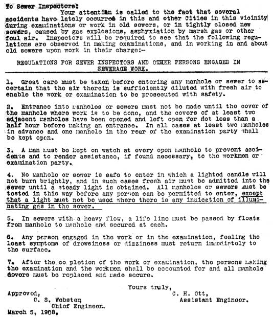
Regulations
for Sewer Inspectors, 1908
This vintage document include this caveat:
"No manhole or sewer is safe to enter in which a lighted candle will not
burn brightly.
City
Job Announcement for Sewer Crawler, 1968.
Thanks
for Joe and Milton Shapiro for this piece of sewer trivia, which is linked at
the top of the "Down Under" page.
"The
Journey of Your Flush"
A map on display at the Fairmount Water
Works Interpretive Center, following the ten mile, six hour journey of a flush
from the FWWIC to the Southwest Sewage Treatment Plant.
Reports
from the Chief Engineer and Surveyor of the City of Philadelphia 1854-1950
In the second half of the 19th century and into the first half of the 20th century,
the bailiwick of the City's Chief Engineer & Surveyor and his subordinates,
the district surveyors, was nothing less than the creation of Philadelphia as
we know it. These reports, in PDF format, cover that work, from bridges and streets
to providing drainage for both stormwater and sewage.
Excerpts
from the Annual Report of Strickland Kneass, Chief Engineer & Surveyor for
Philadelphia, 1856 to 1870
Kneass was the City's first surveyor after
Consolidation expanded the City territory from two to 129 square miles. Many of
these excerpts relate to problems with sewer construction, the health problems
of sewage pollution in streams, and the problems related to the shift from privies
to water closets.
State of the
Schuylkill River in 1876: Sewage pollution and possible remedies
An
excerpt from the PWD Annual Report for 1876.
Future
Sewerage Requirements of the City of Philadelphia, 1880.
A report
that outlined the system of interceptor sewers that was eventually adopted and
implemented by the city.
Philadelphia
Drainage in 1880
An excerpt from Report on the Social Statistics
of Cities, published by the US Census Bureau and edited by George Waring Jr.,
the country's leading sanitary engineer at that time. See also companion from
this Census report, Philadelphia
in 1880.
Report
on the Collection and Treatment of the Sewage of the City of Philadelphia.
Excerpts from report published by the City in 1914 that outlined plans
for sewage interceptors and sewage treatment plants.
Board
of Health Newspaper Clipping Scrapbooks at City Archives of Philadelphia 1891-1908
This selective list of clippings includes items relating
to sewers, water pollution, water filtration, typhoid and other diseases, and
anything else that caught my fancy.
Report
of a Sanitary Survey of the Schuylkill Valley, 1884
This exhaustive
69 page report of this survey covers the entire valley from the source of the
river to the Fairmount Water Works. A summary of the report in 12 color charts,
published in the PWD 1883 annual report, can be accessed in a compressed black
and white PDF or as 12 separate JPG images that are about 125 kb each.
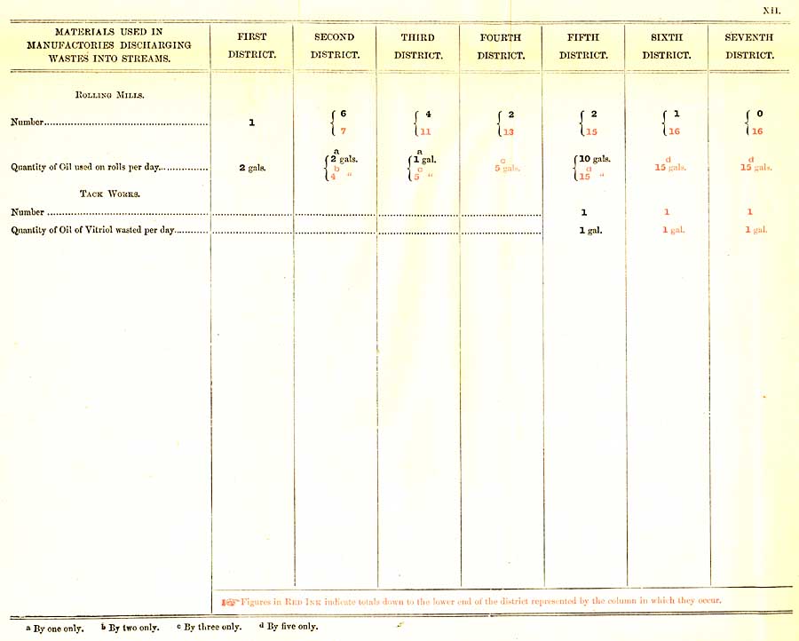
Petition
and Plan of Manufacturers along the Schuylkill River, 1868.
Including an editorial deriding the self-serving nature of the petition, in which
the manufacturers suggested piping water to Philadelphia from upstream so they
could continue polluting the river within the City limits.
Purity
of Water: The Schuylkill in 1866.
An excerpt from the 1866
PWD Annual Report on the condition of the Schuylkill River, then as now the source
of much of the City's water.
If
the People Will It that the Streams of Pennsylvania Shall Be Clean, IT CAN BE
DONE
Address by Grover C. Ladner, Esq. to Izaak Walton League, 1929,
concerning the Pure Streams Law and pollution of the Schuylkill River.
Redemption
of the Lower Schuylkill: The River As It Was, The River As It Is, The River As
It Should Be
A 1924 book by John Frederick
Lewis, about the deplorable state of the river below the Fairmount Dam and what
might be done to restore it.
When
it rains, it pours: Understanding the importance of stormwater runoff
An article originally written for Green Scene, and reprinted as a fact sheet by
the Pennsylvania Horticultural Society, on the problems of uncontrolled urban
stormwater runoff (in particular combined sewer overflows), and some of the steps
that PHS and PWD are taking to alleviate it.
Stormwater
Song Lyrics by John and Jan Haigis.
John and Jan are Darby, PA residents
who have a great interest in history, music, and, the environment. As co-presidents
of the Darby Creek Valley Association, they have a great concern for various issues
affecting water quality in the creek, which flows from Chester County into the
Delaware River at Tinicum, south of the Philadelphia International Airport. They
wrote these songs to promote the preservation of the watersheds they love.
Song
of the Sewer, performed by Art Carney.
(aka Ed Norton, the sewer worker
in the 1950s TV Show, "The Honeymooners"). This song was first brought
to my attention by Joe Shapiro, volunteer in the PWD Archives, who loves good
music but also loves oddities like this. Now, thanks to YouTube, I can legally
share this gem with you, my fellow sewer aficionados. I consider it my unofficial
theme song.
Water Supply History
Two items in one PDF (9 mb): "Reports on coal-dust pollution", and "Report of visit [to collieries in Schuylkill County and adjacent areas] of June 22-25, 1896", by John C. Trautwine, Jr., Chief of the Bureau of Water, City of Philadelphia AND "Conclusions reached respecting sand filtration in Philadelphia," by Allen Hazen, C.E. with accompanying "Map of Philadelphia showing present intakes, pumping stations and reservoirs together with proposed filters and connections"
The Water
Works of the City of Philadelphia: The Story of their Development and
Engineering Specifications
A history of pumping engines used in the Philadelphia water system from
its beginnings in 1801 up to 1931. Includes a remarkable chart summarizing
the entire history, and numerous illustrations. Compiled by Walter A.
Graf, Staff Engineer with the assistance of Sidney H. Vought and Clarence
E. Robson, of the Budd Company, Philadelphia. Created from original volume
housed at the Historical Society of Pennsylvania, HSP Catalogue No. WZ
23591 (4th Fl. Folio).
Watering Committee Report,
1816
This facsimile PDF, with all text recognized, documents the start of the
Fairmount Water Works and other aspects of the city's water supply system.
Full title: "Report of the Watering Committee to the Select and Common
Councils, read January 25, 1816. Philadelphia: Printed by William Fry,
Walnut, near Fifth Street, 1816."
Philadelphia:
A periodical published by the City Government, 1909-1911
While in some ways simply a public relations organ for the City, this
magazine also includes some valuable information not easily found elsewhere,
as well as many photographs, maps and other illustrations of the topics
presented. Each issue generally focuses on a single aspect of the city.
Three facsimile PDFs cover the water supply and sewer system, and I have
also included a list of all volumes I was able to locate.
The
Upper Perkiomen Valley as a Source of the Water Supply for Philadelphia
(1894) by Jonathan Faust, M.D.
A critique of the Philadelphia Water Department plans to dam the Perkiomen
(a Schuylkill River tributary) to supply water via aqueduct to Philadelphia.
Page also includes information about the Green Lane Dam, which was built
on the Perkiomen between 1955 and 1957 by the Philadelphia Suburban Water
Company.
Newspaper
Clipping Scrapbook (Part 1) of Frederic Graff Jr.,
1854-1857
This is the first part of a two part collection of clippings collected
by Frederick Graff Jr., Chief Engineer of the Philadelphia Water Department
during the middle of the 19th century. Conserved, mounted and bound, the
scrapbook contains 130 pages of clippings on a wide variety of topics,
reflecting Graff's wide interests and activities. PDF images of each scrapbook
page are attached. The second volume can also be accessed from this page.
Torresdale:
The Push-Button Water Treatment Plant
Well-illustrated and large-format 1959 brochure from the Philadelphia
Water Department touting the automation of the Torresdale Water Treatment
Plant, the largest of three plants in the city.
Kensington
Water Supply (1883) By
William W. Van Baun, M.D.
Located on
the Deleware River just below where the Aramingo Canal emptied into the river,
the Kensington Water Works served up a disgusting brew of polluted drinking water
for decades after it was opened in 1851. Health records from the period show a
higher death rate from typhoid fever and other water-borne diseases in the areas
served by this water works. The Board of Health advocated its closure many times,
as did independent physicians such as the author of this article. Unfortunately,
the works were not completely abandoned until 1890.
1889
Report on Philadelphia's Water Supply
by the Board of Health
This Board of Health
Report focuses on typhoid fever and tries to carefully prove that the pollution
of the water supply with sewage is causing this disease. This is an accepted fact
today, but many people still needed to be convinced of this in 1889. This was
one of many reports that led to the ultimate filtration of the water supply in
the early 20th century.
1931
Report on Water Supply and Sanitation (including sewers and sewerage)
The full citation of this report: "Semi-final draft
of report on the water supply and sanitation problem in the Philadelphia Tri-State
District. Supplement to chapter X of the regional plan report approved by the
Committee on Water Supply and Sanitation, June 30, 1931. Prepared for submission
to the Water Supply and Sanitation Committee, August 1931. The Regional Planning
Federation of the Philadelphia Tri-State District, 1700 Fox Building, Philadelphia."
This was among the final scanning projects undertaken by long-time PWD Archives
volunteers, Dan and Pauline Greene.
News
clippings related to a new water supply for Philadelphia, 1944-1946.
This series of clippings documents the city's last search for a new water supply
to replace the grossly polluted Schuylkill and Delaware Rivers. While the 194-page
PDF is a bit unwieldy (and clocks in at 22 mb), it is a wealth of information
for anyone interested in public works in this region at that time. This was among
the final scanning projects undertaken by long-time PWD Archives volunteers, Dan
and Pauline Greene.
History
of East Park Reservoir 1869-1889
Jane Mork Gibson, historical consultant
for PWD, compiled this report on the reservoir (in Fairmount Park, Philadelphia)
from its conception through construction and finally its opening in 1889.
"The Water Supply
of the City of Philadelphia by a proposed Aqueduct from Norristown Dam, and the
Acquisition of the Works of the Schuylkill Navigation Co. 1891"
This plan was never implemented, but left behind a series of sixteen beautifully
rendered plans and maps showing details of the Schuylkill River watershed; the
canals, locks, dams of the Schuylkill Navigation company; and gate-houses and
other buildings designed by Philadelphia architect Frank Furness.
PWD
Annual Report Indexes 1898-1913
Thanks to PWD Archives Volunteer Christiane
Metz, for compiling these indexes for the years covering the construction of PWD's
filtration system. Reports for these years are literally crammed with charts,
graphs and other illustrations, all of which are described.
1,580
PWD Photographs (1895-1909), on PhillyHistory.org: The Pauline and Daniel Greene
Glass Plate Negative Collection
These photographs, created from 8"x10"
glass plate negatives, mostly document the construction of the city's then-new
drinking water filtration system. The small images presented on PhillyHistory
give only a glimpse of the information recorded in these pictures, which show
everything from landscapes and streetscapes that are long gone, turn-of-the-century
construction methods that straddled the transition period between horsepower and
automotive machinery, down to the hand tools, clothing, and hair styles of the
foreman and workmen. In some images, labels on equipment such as cranes, steam
engines, and wheelbarrows are clearly discernible. This link will take you to
a web page that includes sample high-resolution images; background about the discovery
of the negatives and the 20-year process of cleaning, cataloguing, scanning, and
getting them online; and a tribute to long-time PWD volunteers Pauline and Dan
Greene.
1848 Dauguerreotype
View of Fairmount Water Works and Vicinity
Including Lemon Hill, Schuylkill
Navigation Company locks and canal, and various buildings in the area north of
the Water Works once called "the Flatiron." Images reproduced with permission
of the George Eastman House, Rochester, New York.
Philadelphia Water Department Library Catalogue: A PDF listing more than 1,500 publications in the collection of the Philadelphia Water Department. Thanks to PWD volunteer Joe Shapiro for cataloguing these volumes.
The Fairmount Water Works, by Jane Mork Gibson. From Bulletin, Philadelphia Museum of Art, Volume 84, Numbers 360, 361 Summer 1988. Published for the exhibition The Fairmount Water Works, 1812-1911 (July 23-September 25, 1988). The original publication contains many illustrations and informative captions, a checklist of the exhibition, and a preface by Anne d'Harnoncourt, none of which is included here, But even without the illustrations, the following text stands as the best and most complete history of Fairmount, from Jane Mork Gibson, the site's most knowledgeable historian.
Philadelphia's
Water and Sewer History: A Digital Exhibit
Two virtual exhibits, based
on "Clean Water For Life: Philadelphia Water Department 1801-2001,"
an exhibit still on view at the Municipal Services Building, 1401 Arch Street,
Philadelphia.
Drainage
for the City replaces a previously-posted version that did not include
all the exhibit images. I co-wrote the text and located most of the illustrations
for this part of the exhibit.
Water for
the City: This comprehensive history of the Philadelphia water supply
is based on a quarter-century of research by historian Jane Mork Gibson.
1883
Report of William Ludlow, Chief Engineer of the
Philadelphia Water Department.
Ludlow is particularly astute in his discussion
of the need for water conservation and the sewage pollution of the city's river-based
water supply.
Reports
relating to the development of the Philadelphia Water System, 1798-1875.
From a bound volume once the property of John L. Ogden, PWD Chief Engineer
from 1886 to 1895. Facsimiles in PDF format have been made of most of the reports,
including some of the earliest reports of the Watering Committee of the Select
and Common Councils (predecessor of the present-day PWD). This link takes you
to an index page for the PDF files.
1886
Report on a New Water Supply for Philadelphia
Rudolph Hering's 1886
proposal is one of the most comprehensive of the many plans for alternative water
supplies the City commissioned between 1868 and 1946. It is certainly among the
best documented, with a plethora of tables, charts and photographs reproduced.
It discusses the outlying watersheds from which Hering thought Philadelphia should
obtain its water, and includes detailed costs estimates of the many reservoirs,
down to the number of buildings that would have to be flooded out in the process.
In the end, the City rejected this plan and all the others, choosing instead to
continue using the Schuylkill and Delaware rivers as its water sources.
Maps
relating to 1886 Report on a New Water Supply for Philadelphia
This
collection of large-scale images includes a fascinating collection of detailed
topographic maps (dated 1887) that cover portions of Bucks and Montgomery counties,
including the watersheds of Perkiomen Creek and Neshaminy Creek. Other documents
include maps and aqueduct profiles that summarize, in visual form, this never-implemented
plan for a new upstate water source. See the link above for more information on
this proposal.
Surveys
for a Future Water Supply of the City of Philadelphia: Annual Report of Progress
during 1884, by Rudolph Hering, C.E., Engineer in Charge.
The excerpts
included here describe in detail the condition of various watersheds in the vicinity
of Philadelphia, which the City considered using for an alternative water supply.
Most of these watersheds, unlike the territory draining into the Schuylkill, were
relatively unspoiled in 1884. This report is also a preliminary portion of the
1886 Water Supply Report, also by Hering, included above.
Frederic
Graff Scrapbooks: Index to Part 1: 1854-1857
Frederic
Graff Scrapbooks: Index to Part 2: 1858-1871
Graff was PWD Chief Engineer during part of the time these scrapbooks
cover. They include clippings on a variety of local and national topics,
reflecting Graff's wide interests and activities.
PWD Newspaper
Clipping Scrapbooks: Index to Volume for 1920-1929
This volume is one of several that cover the water-related news of the
period from 1906 to 1945.The index to this 363-page volume includes a
wealth of information about the various water supply woes of the 1920s.
Interview with
Samuel Baxter
Baxter was Water Commissioner for more than 20 years,
and involved in building water and sewer infrastructure for more than 50 years.
This interview was first published by the Public Works Historical Society.
Purity
of Water: The Schuylkill in 1866.
An excerpt from the 1866
PWD Annual Report on the condition of the Schuylkill River, then as now the source
of much of the City's water.
The
Present Water Supply 1884
Excerpt from the Annual Report of William
Ludlow, Chief Engineer of the Philadelphia Water Department for the year 1884.
An overview of the failed attempts to keep the Schuylkill River's Fairmount pool
(from which 80 percent of the City's water was derived) free from pollution. Of
special interest is the discussion of sewage pollution, and the dangers it posed
to the health of the population.
Petition
and Plan of Manufacturers along the Schuylkill River, 1868.
Including an editorial deriding the self-serving nature of the petition, in which
the manufacturers suggested piping water to Philadelphia from upstream so they
could continue polluting the river within the City limits.
Hydrographical
Survey of the Schuylkill River, 1866.
Map and
accompanying text give a detailed description of the state of the river in Philadelphia,
above the Fairmount Dam, in a report by PWD Chief Enginer H. P. M. Birkinbine.
Historical
Overview of the Schuylkill River as Water Supply.
A brief history
with links to a number of illustrations.
Schuylkill River
(For more maps, see MAPS link)
Two items in one PDF (9 mb): "Reports on coal-dust pollution", and "Report of visit [to collieries in Schuylkill County and adjacent areas] of June 22-25, 1896", by John C. Trautwine, Jr., Chief of the Bureau of Water, City of Philadelphia AND "Conclusions reached respecting sand filtration in Philadelphia," by Allen Hazen, C.E. with accompanying "Map of Philadelphia showing present intakes, pumping stations and reservoirs together with proposed filters and connections"
Schuylkill River. Wissahickon Creek, Phila., Pa. to Norristown, Pa.,
1913.
Surveyed by J. W. Thompson, Junior Engineer, Aug. to Dec. 1913. L. D.
Shuman, Assistant Engineer. In 18 sheets. [Includes Index map (Sheet 14),
descriptions of triangulation stations (Sheets 15, 16 and 17) and Freshet
Data (Sheet 18) listing all the major floods affecting this section of
the river to 1913. Maps show topography of shoreline, soundings, footprints
of riverfront buildings, railroads, canal, locks, dams, tributary streams,
and many other details.
A River Again: The Story of the Schuylkill River Project, by Chari Towne of the Delaware Riverkeeper Network. Link to a free PDF download page of this book, which documents the state and federal project in the 1940s and 1950s to remove millions of tons of coal waste that was choking the Schuylkill River.
Brief Summer
Rambles Near Philadelphia (1881).
Described in a series of letters written for The Public Ledger during
the summer of 1881. By Joel Cook. Philadelphia: J. B. Lippincott &
Co. 1882. Most of these rambles were outside the city; the first four,
which are reproduced below, describe the scenery in Fairmount Park, Laurel
Hill Cemetery, along Wissahickon Creek, and along the Delaware River from
Philadelphia to Trenton, as seen from a steamboat.
The
Upper Perkiomen Valley as a Source of the Water Supply for Philadelphia
(1894) by Jonathan Faust, M.D.
A critique of the Philadelphia Water Department plans to dam the Perkiomen
(a Schuylkill River tributary) to supply water via aqueduct to Philadelphia.
Page also includes information about the Green Lane Dam, which was built
on the Perkiomen between 1955 and 1957 by the Philadelphia Suburban Water
Company.
Geology
of Pennsylvania: A Government Survey (1858).
Excerpts and images
including geological and pictorial representations of Schuylkill River and Wissahickon
Creek, descriptions of the Potomac, Susquehanna, Delaware, and Allegheny watersheds
in Pennsylvania, and locations of quarries in Philadelphia and vicinity.
Fairmount
Dam Fishway on the Schuylkill.
Information on the new fishway, opened
in May 2009 to replace the Fairmount Dam Fish Ladder, and Includes photographs
and videos of fish (and one otter) passing through the fishway. Also many links
to other fish- and fishing-related pages. Among the links:
2008 PowerPoint
presentation on Fish Passage at Fairmount by Lance Butler and Joe Perillo, and
2005-2006 Fish Counts by Species at Fairmount Fish Ladder.
Fishing
in Philadelphia: Photographs from the Philadelphia Anglers Club.
Includes
photos of huge fish being taken out of the Schuylkill River and elsewhere in Philadelphia.
A second page of photos, Catch and Release,
documents big fish that took the bait more than once, and discusses the safety
of eating fish caught in urban environments. Thanks to Louis Cook of the
Philadelphia Anglers Club for providing information and gathering the photos for
these pages, from fellow Philly anglers Matt Coll, Tan Bui, Aki Mori, Chris McIntee,
Dan Coghlin, Dennis Cook, Enoch Lee, and Jude Becker.
"The
Water Supply of the City of Philadelphia by a proposed Aqueduct from Norristown
Dam, and the Acquisition of the Works of the Schuylkill Navigation Co. 1891."
This plan was never implemented, but left behind a series of sixteen beautifully
rendered plans and maps showing details of the Schuylkill River watershed; the
canals, locks, dams of the Schuylkill Navigation company; and gate-houses and
other buildings designed by Philadelphia architect Frank Furness.
State
of the Delaware River Estuary 2008
This Summer 2008 report, from
the Partnership for the Delaware Estuary (in which the Philadelphia Water Department
is an important participant), details the health of the estuary or tidal portion
of the Delaware River, below the falls at Trenton, NJ. The estuary includes all
of the Schuylkill River Basin, and this report makes a great companion to A
Report on the State of the Schulkill River Watershed: 2002. For more information
on the Delaware Estuary, visit www.delawareestuary.org.
A
Report on the State of the Schuylkill River Watershed: 2002
A comprehensive
overview of the state of the river. Includes informative maps, tables, and other
illustrations. Prepared by the Conservation Fund for the Schuylkill River Watershed
Initiative, a consortium of most of the groups interested in the health of the
river, including PWD.
Railroad
Scenery of Pennsylvania, 1875.
A
section of the volume Philadelphia and Its Environs, and the Railroad Scenery
of Pennsylvania
(Philadelphia: J. B. Lippincott & Co., 1875). The
text and accompanying illustrations provide a fascinating tour, via various Pennsylvania
railroads, of the state's coal mining regions, as well as other sites to be seen
along the way. In my talks about the Schuylkill
River as it flows through Philadelphia, I often mention the so-called "culm"
(small pieces of waste coal) that accumulated around the many coal mines, washed
into the river with every rainfall, and eventually clogged the river upstream
from the Fairmount Dam.
Schuylkill
River in Philadelphia, from Noll's New Official Guide Map of Philadelphia, 1890.
This map shows the many creeks that other maps of the period omitted, as well
as elevation contour lines that give a sense of the rise and fall of the terrain.
The street grid also seems more realistic than other maps, which are often projections
of future development than depictions of what is actually built.
Hydrographical
Survey of the Schuylkill River, 1866.
Map and
accompanying text give a detailed description of the state of the river in Philadelphia,
above the Fairmount Dam, in a report by PWD Chief Enginer H. P. M. Birkinbine.
Purity
of Water: The Schuylkill in 1866.
An excerpt from the 1866
PWD Annual Report on the condition of the Schuylkill River, then as now the source
of much of the City's water.
Views
of the Schuylkill River.
A selection of engravings from various collections.
Historical
Overview of the Schuylkill River as Water Supply.
A brief history
with links to a number of illustrations.
The
Present Water Supply 1884
Excerpt from the Annual Report of William
Ludlow, Chief Engineer of the Philadelphia Water Department for the year 1884.
An overview of the failed attempts to keep the Schuylkill River's Fairmount pool
(from which 80 percent of the City's water was derived) free from pollution. Of
special interest is the discussion of sewage pollution, and the dangers it posed
to the health of the population.
Report
of the Lieutenant of the Schuylkill Harbor Police for the year ending December
31, 1884.
Basically a "crime log" for the year for the
Schuylkill River side of the Port of Philadelphia, then one of the largest and
busiest in the world. A companion is the report of the Delaware Harbor Police.
Report
of a Sanitary Survey of the Schuylkill Valley, 1884
This exhaustive
69 page report of this survey covers the entire valley from the source of the
river to the Fairmount Water Works. A summary of the report in 12 color charts,
published in the PWD 1883 annual report, can be accessed in a compressed black
and white PDF or as 12 separate JPG images that are about 125 kb each.
If
the People Will It that the Streams of Pennsylvania Shall Be Clean, IT CAN BE
DONE
Address by Grover C. Ladner, Esq. to Izaak Walton League, 1929,
concerning the Pure Streams Law and pollution of the Schuylkill River.
Redemption
of the Lower Schuylkill: The River As It Was, The River As It Is, The River As
It Should Be
A 1924 book by John Frederick
Lewis, about the deplorable state of the river below the Fairmount Dam and what
might be done to restore it.
Petition
and Plan of Manufacturers along the Schuylkill River, 1868.
Including an editorial deriding the self-serving nature of the petition, in which
the manufacturers suggested piping water to Philadelphia from upstream so they
could continue polluting the river within the City limits.
Delaware River
(For maps see MAPS link)
Brief Summer
Rambles Near Philadelphia (1881).
Described in a series of letters written for The Public Ledger during
the summer of 1881. By Joel Cook. Philadelphia: J. B. Lippincott &
Co. 1882. Most of these rambles were outside the city; the first four,
which are reproduced below, describe the scenery in Fairmount Park, Laurel
Hill Cemetery, along Wissahickon Creek, and along the Delaware River from
Philadelphia to Trenton, as seen from a steamboat.
Geology
of Pennsylvania: A Government Survey (1858).
Excerpts and images
including geological and pictorial representations of Schuylkill River and Wissahickon
Creek, descriptions of the Potomac, Susquehanna, Delaware, and Allegheny watersheds
in Pennsylvania, and locations of quarries in Philadelphia and vicinity.
State
of the Delaware River Estuary 2008
This Summer 2008 report, from the
Partnership for the Delaware Estuary (in which the Philadelphia Water Department
is an important participant), details the health of the estuary or tidal portion
of the Delaware River, below the falls at Trenton, NJ. The estuary includes all
of the Schuylkill River Basin, and this report makes a great companion to A
Report on the State of the Schuylkill River Watershed: 2002. For more
information on the Delaware Estuary, visit www.delawareestuary.org.
Delaware
River Images
From various collections, these
are divided into the folowing pages:
General
Views
Aerial Views from the PNI Library
Views of Smith and Windmill Islands
Delaware
River Steamboats, 1876.
A description from a Centennial guidebook,
with illustrations.
Report
of the Lieutenant of the Delaware Harbor Police for the year ending December 31,
1884
Basically a "crime log" for the year for the Delaware
River side of the Port of Philadelphia, then one of the largest and busiest in
the world. A companion is the report of the Schuylkill Harbor Police.
Photographs and engravings
Scenes
on 300 block of South 44th Street, West Philadelphia, 1914-1916.
From photograph album of Minetta Baker, 322 S. 44th Street. Thanks to Charlotte
Elsner for rescuing these photographs and passing them on to me.
Fred
D. Borrelli, Dedicated Philadelphia Water Department employee, 1938-1963.
A remembrance by Bob Borrelli, who provided several anecdotes and vintage
photographs of his father as a child in West Philadelphia and at work for the
city.
1,580 PWD Photographs
(1895-1909), on PhillyHistory.org: The Pauline and Daniel Greene Glass Plate Negative
Collection
(See listing under "Water Supply," above, for
a full description.)
Aramingo
Canal: Then and Now.
Photos of the Aramingo Canal (Gunner's Run)
being converted into a combined sewer, 1900-1902, along with modern photos showing
an excavation of a section of the canal, December 2008. Thanks to Doug Mooney
of URS Corp., who headed the archaeological investigation, for inspiring this
page and providing modern photos, and to A. Leonard Pundt, for providing additional
modern photos.
Railroad
Scenery of Pennsylvania, 1875.
A
section of the volume Philadelphia and Its Environs, and the Railroad Scenery
of Pennsylvania
(Philadelphia: J. B. Lippincott & Co., 1875). The
text and accompanying illustrations provide a fascinating tour, via various Pennsylvania
railroads, of the state's coal mining regions, as well as other sites to be seen
along the way. In my talks about the Schuylkill
River as it flows through Philadelphia, I often mention the so-called "culm"
(small pieces of waste coal) that accumulated around the many coal mines, washed
into the river with every rainfall, and eventually clogged the river upstream
from the Fairmount Dam.
1848
Dauguerreotype View of Fairmount Water Works and Vicinity
Including
Lemon Hill, Schuylkill Navigation Company locks and canal, and various buildings
in the area north of the Water Works once called "the Flatiron." Images
reproduced with permission of the George Eastman House, Rochester, New York.
Images
from the Castner Scrapbooks, Free Library of Philadelphia Print & Picture
Collection.
These
are divided into the following pages:
Delaware
River: General
Delaware River:
Smith and Windmill Islands
Augustus
Kollner: Watercolors and Lithographs, and
Frank H. Taylor: Watercolors of West Philadelphia.
Picturesque
America: D. Appleton & Co., 1873
A collection of engravings of
scenes along the Schuylkill and Delaware rivers, Wissahickon Creek and in Fairmount
Park. From the collection of Adam Levine.
Photographs
of underground sewer inspections
Photographs used through the courtesy
of the Philadelphia Inquirer and Daily News library. This small collection illustrates
my article about the sewer walk I took in 1997, found at Down
Under!
Engravings
from the Magee Guide to Philadelphia, 1876.
and
Engravings from
Philadelphia and Its Environs, 1875.
Selections focusing on the city's streams, rivers,
and parks, including Fairmount Park.
List
of Illustrations in History of Philadelphia: 1682-1884.
Indexes to the hundreds of images in all three volumes of this pre-eminent
historical work, commonly known by its authors' last names, Scharf and Westcott.
Many are fine full page engravings.
Philadelphia
Historical Miscellany
(For maps see MAPS link)
Encyclopedia of
Philadelphia by Joseph Jackson
Volume 1 of 4, covering Abattoir to Bonnafon. Harrisburg: The National
Historical Association, 1931. A facsimile PDF, with all text recognized,
of the first volume of this informative encyclopedia. If I get even a
little encouragement I might digitize the other three volumes.
Philadelphia:
A periodical published by the City Government, 1909-1911
While in some ways simply a public relations organ for the City, this
magazine also includes some valuable information not easily found elsewhere,
as well as many photographs, maps and other illustrations of the topics
presented. Each issue generally focuses on a single aspect of the city.
Three facsimile PDFs cover the water supply and sewer system, and I have
also included a list of all volumes I was able to locate.
Brief Summer
Rambles Near Philadelphia (1881).
Described in a series of letters written for The Public Ledger during
the summer of 1881. By Joel Cook. Philadelphia: J. B. Lippincott &
Co. 1882. Most of these rambles were outside the city; the first four,
which are reproduced below, describe the scenery in Fairmount Park, Laurel
Hill Cemetery, along Wissahickon Creek, and along the Delaware River from
Philadelphia to Trenton, as seen from a steamboat.
Scrapbook of
Survey Notices, 1871-1886, Compiled by the Dept. of Surveys, City of Phila.
Scrapbook of broadside notices posted in affected neighborhoods
to inform residents of meetings of the Board of Surveyors of the City
of Philadelphia at which would be discussed proposed additions or changes
to the official city plans created by the city's Department (or Bureau)
of Surveys. Changes could include the lines of streets and the grade regulations.
Includes index to the surveys by official City Plan number. Reads part
of a typical broadside (p. 12): "At the said meeting the board will
hear the objections of any freeholders to the final confirmation of said
plans, and in the meantime they may be seen at the Survey Department,
No. 224 South Fifth Street."
Philadelphia:
A periodical published by the City Government, 1909-1911
This monthly periodical, while in some ways simply a public
relations organ for the City, also includes some valuable information
not easily found elsewhere, as well as many photographs, maps and other
illustrations of the topics presented. Three of the issues covered water
and sewer, and they are reproduced as PDFs. Also included is a lists of
all the copies of Philadelphia I found, with a brief description
of the subject of each volume.
Philadelphia
Farms, Newspaper Reports, 1929-1980.
Text of four newspaper clippings
from the Bulletin Collection, Temple University Libraries Urban Archives.
Special
Report on the City Plan by the City Parks Association of Philadelphia.
by J. Rodman Paul and Andrew Wright Crawford. The City Parks Association,
an advocacy group founded in 1889 which supported the creation of public parks
and playgrounds in Philadelphia, published this Special Report in 1902. The authors
severely criticized what they call the city's "gridiron" system of streets,
especially the effect of such a rigid plan on the natural landscape and topography.
The many illustrations show how destructive such a system tends to be, and how
even slight deviations from the grid can be a great improvement.
Railroad
Scenery of Pennsylvania, 1875.
A
section of the volume Philadelphia and Its Environs, and the Railroad Scenery
of Pennsylvania
(Philadelphia: J. B. Lippincott & Co., 1875). The
text and accompanying illustrations provide a fascinating tour, via various Pennsylvania
railroads, of the state's coal mining regions, as well as other sites to be seen
along the way. In my talks about the Schuylkill
River as it flows through Philadelphia, I often mention the so-called "culm"
(small pieces of waste coal) that accumulated around the many coal mines, washed
into the river with every rainfall, and eventually clogged the river upstream
from the Fairmount Dam.
Funeral
receipts from a Philadelphia family: 1849, 1891 and 1934
and
an 1897 advertisement for Laurel Hill Cemetery
Profile
of Queen Village in Philadelphia
and
real estate advertisements from the Philadelphia Bulletin, June 19, 1966.
History
of Philadelphia 1609-1884.
The
preface and two chapters from this three-volume comprehensive history of early
Philadelphia: Chapter 1 (Topography)
and Chapter 2 (Manners and Customs of
the Primitive Settlers). Als
included is a list
of illustrations in the books.
Philadelphia
brick and cobble-stone: A vision of arctic climates
Chapter XI of
Town Geology: The Lesson of the Philadelphia Rocks, an 1885 book by Angelo
Helprin, "Professor of Invertebrate Paleontology at, and Curator-in-Charge
of, the Academy of Natural Sciences of Philadelphia."
History
of Belfield, by Sarah Logan Wistar Starr
1934
booklet about this estate, now part of the LaSalle University campus, in Phildelphia's
Olney section. Belfield and Little Wakefield still exist, as do remnants of the
Belfield's gardens, which are on a steep hillside in the Wingohocking Creek valley,
overlooking a section of Belfield Avenue (beneath which the creek now flows in
a large sewer). In the early 19th century Philadelphia artist
Charles Willson Peale lived on the estate.
Our
City of Tomorrow
From March 1930, this 12-part
series appeared in the Philadelphia Public Ledger.
It described grand plans developed by planners in the Regional Planning Federation
of the Philadelphia Tri-State District, which included Philadelphia and surrounding
counties in Pennsylvania, Delaware and New Jersey. Article topics included water
supply and sewage problems, zoning, the Hog Island shipyard, growth in Delaware
County, Pa., parks and forest preserves, airports, bypass highway and scenic parkway
construction, and industrial, port and railroad development. This series is remarkable
as much for the dreams of the planners as for the many ideas that never made it
off the drawing board.
Reprint of two pamphlets that Horace Smith, in his Preface, claims were influential in the debates that led to the creation of Fairmount Park: Full titles--Keyser: Lemon Hill in connection with the efforts of our citizens and Councils to obtain a public park (1856), and Cochran: Fairmount Park: A necessity for the health and recreation of the present and future population of the city (1872).
Guide
to the City Hall Philadelphia. 1908. Issued by Alfred S. Eisenhower, Chief of
Bureau of City Property
An early guidebook to City Hall, with a history
of the 25-year construction project.
Philadelphia
in 1880
An excerpt from Report on the Social Statistics of Cities,
published by the US Census Bureau, that provides a detailed portrait of the city
and its institutions. See also companion from this Census report, Philadelphia
Drainage in 1880.
Philadelphia
in 1890
The statistics of the City, from streets to wharves to sewers,
as reported for the 1890 Census. Published as an appendix to the 1890 Annual Report
of the Bureau of Surveys.
2,000
turn out for 'Be-In'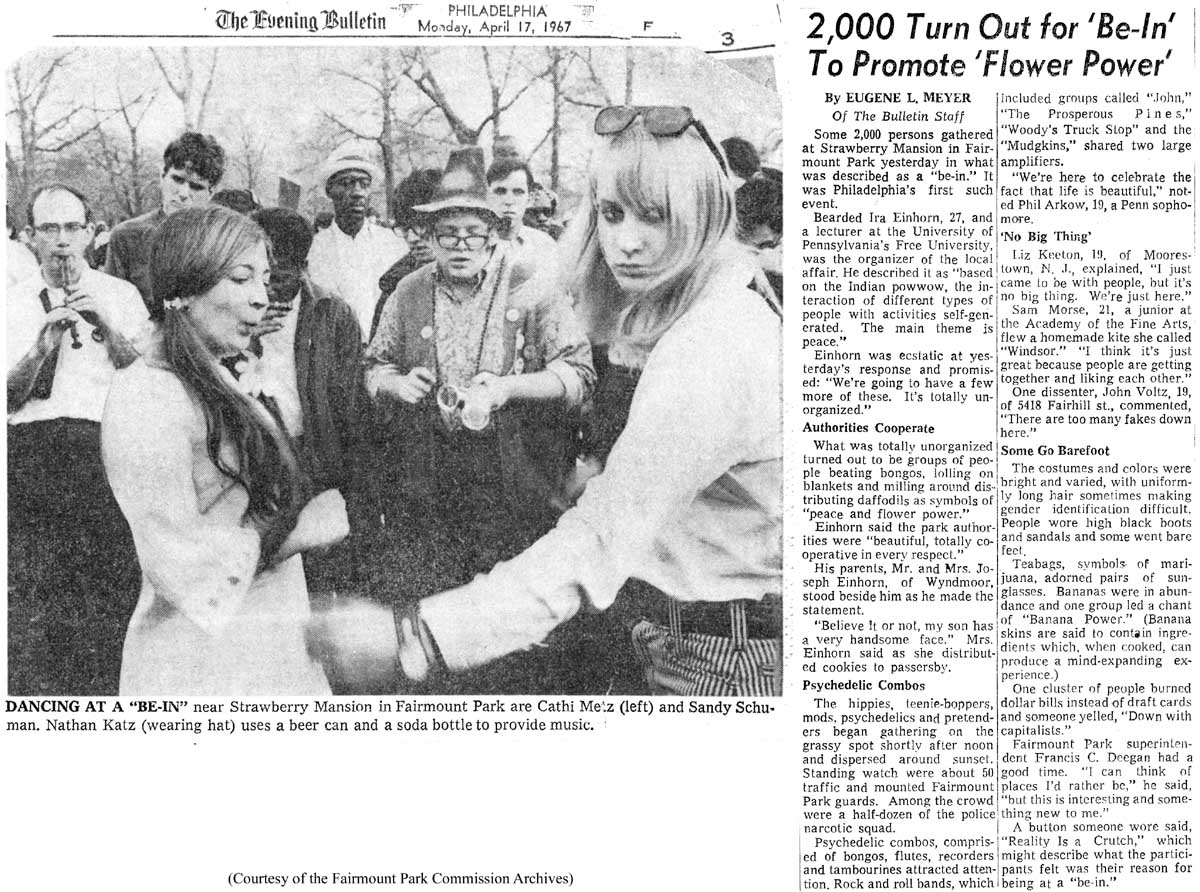 to promote 'Flower Power'
Article and photograph
from the Philadelphia Evening Bulletin, April 17, 1967. The event, held
in Fairmount Park, was organized by Ira Einhorn and attended by "hippies,
teenie-boppers, mods, psychedelics and pretenders." Thanks to Rob Armstrong
of the Fairmount Park Commission Archives for sharing this historic gem. Link
is to a JPEG image of the original article.
Articles on related subjects by Adam Levine
Sewers,
Pollution, and Public Health in 19th Century Philadelphia by Adam Levine
This article first appeared in the May 2010 issue of Pennsylvania Legacies, published
by the Historical Society of Pennsylvania.
When
it rains, it pours: Understanding the importance of stormwater runoff
An article originally written for Green Scene, and reprinted as a fact sheet
by the Pennsylvania Horticultural Society, on the problems of uncontrolled urban
stormwater runoff, and some of the steps that PHS and PWD are taking to alleviate
it.
Down Under: My trip
through a Philadelphia sewer
From the Philadelphia City Paper
(1997)
Drought and
Gardeners
From the newsletter of the Hardy Plant Society/Mid-Atlantic
Group (2004)
Suburban
Sprawl: Turning the tide against poorly planned development
From Green
Scene, April 2005
Profiles
of Gardens and Gardeners
A selection of articles from past years.
Watersheds
An attempt to relate the complicated topic of watersheds to the home gardener,
and to do it in
less than 1600 words. Originally from Green Scene, November
1999.
![]()
Contact
Adam Levine
P age last modified December 20, 2014